BLUF: To be clear, I don't see any reason to think the military shot down an ET or whoever, just that they probably knew what they were shooting at and I wanted to CTR on why that is probably the case.
I won't pretend to have
any idea about what structural info modern radar can resolve, but the linked-to Wen Jiang, Yanping Wang et al. paper doesn't give examples of a flying object being identified, much less imaged, by radar operators "blinded" to the nature of the object (though I guess the authors are attempting to contribute to the development of such a capability).

Fair enough, the paper was lacking in some concrete examples. From a different paper, here's a ship being resolved by combining some of the steps described in the other paper.

Simplified processing steps showing the principle of the proposed detection in range-Doppler domain, the clustering of the pixel-based detections to a single object (middle right), the target track transferred from range-Doppler to time domain (bottom right), and the extracted range-compressed ship signals (bottom center) needed for generating a high-resolution ISAR image sequence (bottom left).
And this one shows a couple different aspects of the target.

Range-compressed HH polarized L-band (top right) and X-band data (middle right) of the police ship Bad Bramstedt acquired during a circular F-SAR flight track (left). The azimuth axis covers an observation time of approx. 7 minutes. At the bottom an ISAR image sequence generated from the range-compressed X-band data is shown.
We can get pretty good looking images even without the tech found in modern military jets. It's not picture perfect, but it can give you enough detail to ID the target, and it can get better. The 150 MHz and 384 MHz in the above picture are the LFM bandwidths they are using. The range resolution is inversely proportionally to that (Higher bandwidth = smaller range res). 384 MHz is roughly 40 cm.
For example, here's ultrawideband S & Ku band images of a drone.

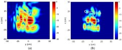
ISAR images of drones under test, courtesy of Li, University of Texas
((a) 3DR solo, (b) DJI inspire 1, (c) Solo ISAR image at 90° (12–15 GHz), (d) Inspire 1 ISAR image at 270° (12–15 GHz), (e) Solo ISAR image at 90° (3–6 GHz), (f) Inspire 1 ISAR image at 270° (3–6 GHz))[
https://ietresearch.onlinelibrary.wiley.com/doi/10.1049/iet-rsn.2018.0020]
Not as great as the ship, but this was with a commercial radar kit from like 2015. (They used this for the 3-6 GHz image, PulsON 410 (P410) UWB transceiver, 4.3GHz C-RF, 1.4 GHz LFM, the caption is confusing for the bandwidth.) You might not be able to tell the brand of drone, but it's at least distinguishable from a balloon or plane.
E.g., the HRRP (high resolution range profile) returned for this notional airliner-shaped target indicates the distribution of scattering centres. But imagine this was a real target in flight; the returned HRRP would change radically depending on the orientation of the target:

Wen Jiang, Yanping Wang et al. recognise this problem in paras. 1 and 3, pg. 6 of their paper.
True, and I highlighted HRRPs because they are pretty basic, but all the different methods are important. From the ship paper,
Ship recognition:
Robust ship recognition is still a current research topic which requires much more effort than classification. High-resolution range profiles (HRRPs), high-resolution ISAR images (or image sequences) and micro-Doppler signatures can, for instance, be used as input for ship recognition algorithms. A fusion with data from other sensors or sources may improve the recognition performance.
It's important to remember that it's not just one jet out there. Sensor fusion is the big thing nowadays. There's no rule that says you can only use the HRRPs or whatever you build yourself. (e.g. multiplatform airborne SAR/ISAR)
But just as the US isn't going to give Russia a decent set of radar returns from different aspects for a B-2 Spirit, it's unlikely that the US has such a rich set of radar returns for specific Chinese surveillance balloons that the exact nature and capabilities of the CONUS intruder could be determined by radar alone, whatever deep learning algorithms/ connectionist architectures used.
Yeah, I could take a guess, but I have no idea for sure tbh. But it'd be pretty crazy to let them meander around the US and partner nations so those types of databases could be built.
By-the-bye, the authors, scientists at the Radar Monitoring Technology Laboratory, North China University of Technology, Beijing, whose paper clearly deals with possible military applications,
might have a sense of humour; on page 26:

To be honest, they got more of a brief frown than a chuckle out of me.
(Edited to add: Amusing/ concerning because the images used by the authors appear to be of the Pentagon, USA).
Friendly/unfriendly rivalry lol.
I'll attach the ship paper because it's pretty cool, but tbh I don't like the drone paper so I won't post it.
And briefly back to my original point, this
- Shape Reconstruction: To reconstruct the shape of an object using radar, advanced signal processing techniques are employed. These techniques involve analyzing the radar data, such as the amplitude, phase, and frequency information of the reflected waves, to extract features that can be used to create a representation of the object's shape. Algorithms and mathematical models are used to interpret the radar data and reconstruct the object's geometry.
is correct.
But still no aliens. Probably.