Hey everyone!
On 08-27-2023 at 18:34 we were driving East through Atlanta, Georgia on I-20 and saw this. By the time we got nearer to it the dip in the highway and trees obscured it entirely. Looks like a smoke plume (near a large insect hit on my friend's windshield) and a silver airship slowly turning. During the brief time I saw it, I didn't see any logos on it and it looked smaller to my eye than the Goodyear Blimp which I've seen many times. Maybe something was going on in whatever Glenwood Park is.
Anyways, I'm not a believer in UFO's but I just thought I'd post it for fun and to see if anyone can figure out which airship it was.
Here are the pics and a pic of where we were on the map. Some I zoomed in with my phone before taking the pic so that's why some are a little muddy. The original images are .heic but those don't seem compatible here? I uploaded the originals but I think Metabunk transcoded them into .pngs. But I'm not certain. My phone has location EXIF data turned off for work reasons but the marker on the map is almost exactly where we were at the time, including the direction we were facing. Thanks! It's my first post with images so I hope I'm doing it correctly.


On 08-27-2023 at 18:34 we were driving East through Atlanta, Georgia on I-20 and saw this. By the time we got nearer to it the dip in the highway and trees obscured it entirely. Looks like a smoke plume (near a large insect hit on my friend's windshield) and a silver airship slowly turning. During the brief time I saw it, I didn't see any logos on it and it looked smaller to my eye than the Goodyear Blimp which I've seen many times. Maybe something was going on in whatever Glenwood Park is.
Anyways, I'm not a believer in UFO's but I just thought I'd post it for fun and to see if anyone can figure out which airship it was.
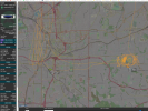
Here are the pics and a pic of where we were on the map. Some I zoomed in with my phone before taking the pic so that's why some are a little muddy. The original images are .heic but those don't seem compatible here? I uploaded the originals but I think Metabunk transcoded them into .pngs. But I'm not certain. My phone has location EXIF data turned off for work reasons but the marker on the map is almost exactly where we were at the time, including the direction we were facing. Thanks! It's my first post with images so I hope I'm doing it correctly.
")