
You are using an out of date browser. It may not display this or other websites correctly.
You should upgrade or use an alternative browser.
You should upgrade or use an alternative browser.
Help me to understand - Photos and Videos with very large numbers of contrails
- Thread starter jtmac
- Start date
Hama Neggs
Senior Member.
What is it you feel you don't understand? That appears to be picture of the sky with contrails. I am aware of no evidence that trails like that are anything other than normal contrails.
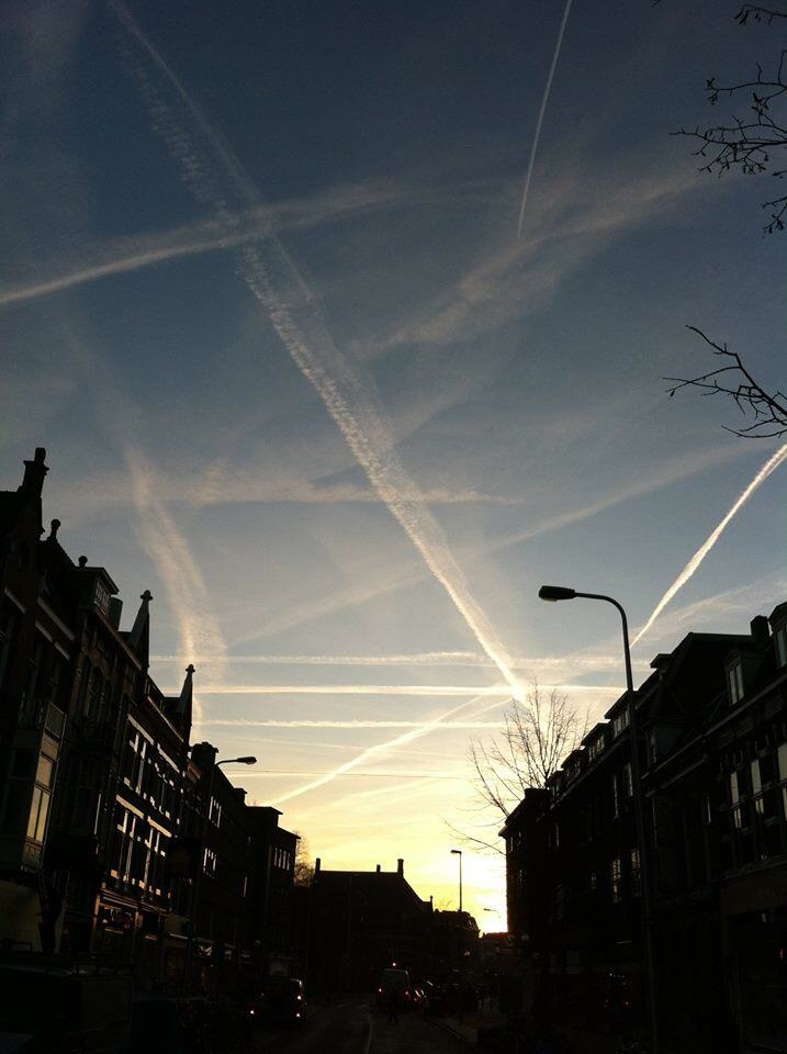
It's one of a series of photos recently posted on Twitter and other places that shows a very large number (over 30) of spreading contrails. There are several more here:
https://twitter.com/CAchemtrails/media
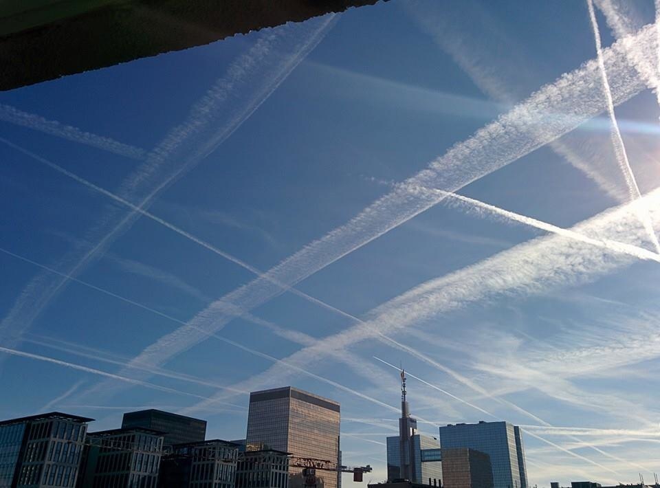
It was obviously taken in a region that gets flyover traffic in multiple directions, and on a day where the conditions were suitable at multiple altitudes for contrail formation. The next photo in the sequence is similar and appears to be London:
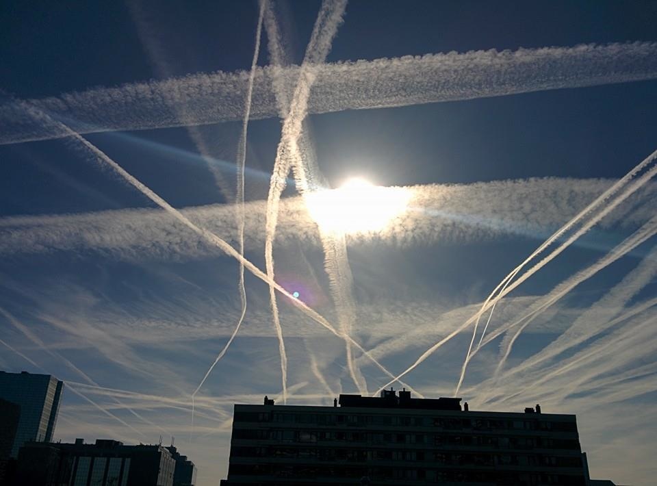
And here's another two photos, which could possibly the same contrails, photographed earlier.
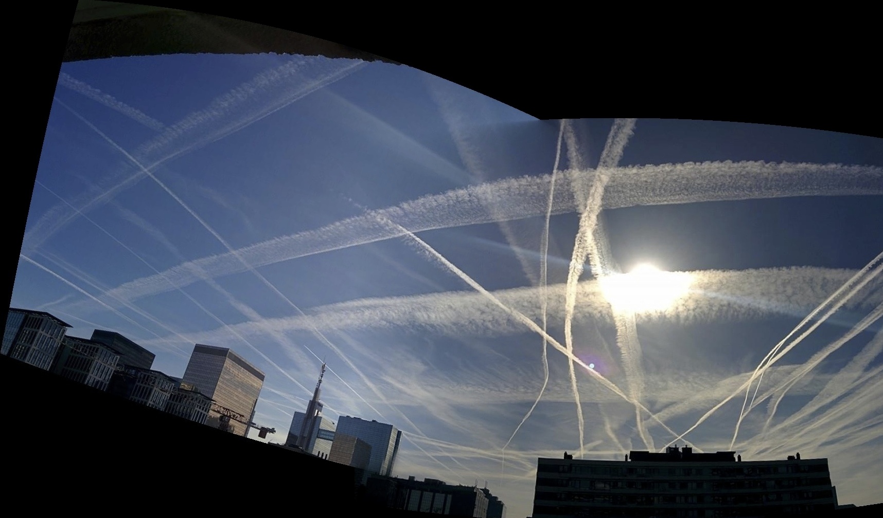
Which can be stitched to form a panorama:
So, as asked above, what don't you understand? The amount of traffic? The persistence? The crossing routes? Why it happens some days and not others? There are a lot of valid questions you could ask, and there are answers, but we need you to be a bit more specific about what it is you want to know.
https://twitter.com/CAchemtrails/media
It was obviously taken in a region that gets flyover traffic in multiple directions, and on a day where the conditions were suitable at multiple altitudes for contrail formation. The next photo in the sequence is similar and appears to be London:
And here's another two photos, which could possibly the same contrails, photographed earlier.
Which can be stitched to form a panorama:
So, as asked above, what don't you understand? The amount of traffic? The persistence? The crossing routes? Why it happens some days and not others? There are a lot of valid questions you could ask, and there are answers, but we need you to be a bit more specific about what it is you want to know.
Last edited:
jtmac
New Member
I guess first, how long is the longest a contrail could possibly last. Under the perfect conditions? Also this bothers me even if it's totally safe. I don't want to see a sky like this it's ugly. And finally, what about the rainwater tests that people post with really high levels of al,ba, and sr? Are they just made up garbage? Thanks for replying.It's one of a series of photos recently posted on Twitter and other places that shows a very large number (over 30) of spreading contrails. There are several more here:
https://twitter.com/CAchemtrails/media
It was obviously taken in a region that gets flyover traffic in multiple directions, and on a day where the conditions were suitable at multiple altitudes for contrail formation. The next photo in the sequence is similar and appears to be London:
And here's another two photos, which could possibly the same contrails, photographed earlier.
Which can be stitched to form a panorama:
So, as asked above, what don't you understand? The amount of traffic? The persistence? The crossing routes? Why it happens some days and not others? There are a lot of valid questions you could ask, and there are answers, but we need you to be a bit more specific about what it is you want to know.
I guess first, how long is the longest a contrail could possibly last. Under the perfect conditions? Also this bothers me even if it's totally safe. I don't want to see a sky like this it's ugly. And finally, what about the rainwater tests that people post with really high levels of al,ba, and sr? Are they just made up garbage? Thanks for replying.
Contrails can last for hours, it depends on the weather conditions at cruise altitude. See:
https://www.metabunk.org/threads/de...-a-study-of-70-years-of-books-on-clouds.3201/
The rainwater tests generally just show expected background levels, or they are contaminated by testing something like pond sludge instead of pond water, or dirty snow. See, for example:
https://www.metabunk.org/threads/debunked-shasta-snow-and-water-aluminum-tests.137/
Another thing with these photos is the perspective. These are not "overhead" contrails, in fact they likely represent contrails that are up to 100 miles away. See this analysis of some similar contrails over London.
http://contrailscience.com/how-far-away-is-that-contrail/
Ideally we'd have the location and date/time of the photo, and so could match it up with weather conditions, flight paths, and satellite photos. Like:
http://contrailscience.com/contrails-above-and-below/
http://contrailscience.com/how-far-away-is-that-contrail/
Ideally we'd have the location and date/time of the photo, and so could match it up with weather conditions, flight paths, and satellite photos. Like:
http://contrailscience.com/contrails-above-and-below/
Do you think anything can be done to make them go away faster? I just wanna see the sky and not all the contrails.
There are various techniques. All of them have costs though. See:
http://contrailscience.com/contrail-avoidance-and-mitigation-techniques/
Here's an analysis of a similar day over south England:
https://www.metabunk.org/threads/flightradar24-satellite-overlay.2007/
https://www.metabunk.org/threads/flightradar24-satellite-overlay.2007/
jtmac
New Member
Oh I see. The last option sounds great with the sound waves or electromagnetic radiation.....but I see your point about the money. Why would commercial airlines pay for that when it has no effect on them. Thiss is the best debunking page I have found. I have more questions but no more time now. I will get back to you. Thanks jtmac.
Lobster Johnson
Member
I live in a small village near Humberside Airport in the UK and we occasionally get that kind of patternation too. Not on the same scale mind but of the type shown here. Now, the airport is not a large one and yet sometimes there are lines upon lines of contrails in the sky and if one where to take a picture of them it could quite easily be taken out of context as the airport wouldn't be in view. It would look to certain groups though as if the NWO where dropping tons upon tons of deadly chemicals upon our heads despite having reached the age of 35 without a single respiratory ailment or abnormal fibre growth (although I can't say with any certainty that I have not been brainwashed).
WeedWhacker
Senior Member
I live in a small village near Humberside Airport in the UK and we occasionally get that kind of patternation too. Not on the same scale mind but of the type shown here. Now, the airport is not a large one and yet sometimes there are lines upon lines of contrails...
It's important to realize that when you see contrails, they are not being formed by the traffic locally arriving/departing at an airport near you.
This is 'flyover" traffic.
If you look at this link:
http://skyvector.com/?ll=53.57456921174049,-0.3510131811667493&chart=304&zoom=4
You will see a Chart of the normal High Enroute Airways, with Humberside centered. Then, you can manipulate the "map" as usual (same as with Google maps, for instance).
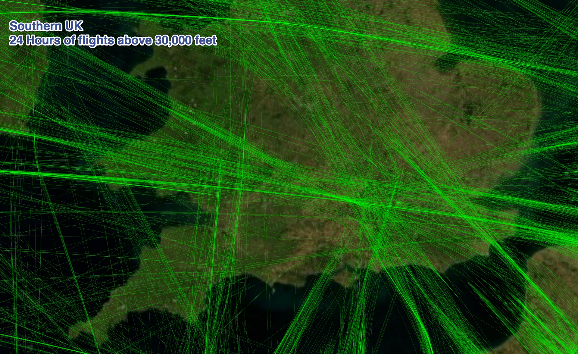
https://www.metabunk.org/threads/visualizing-flight-paths-above-30-000-feet.812/
That's why I made these images which ONLY show the flight tracks of planes when they are over 30,000 feet (notice you see a lot of them stop short of the coastal cities).
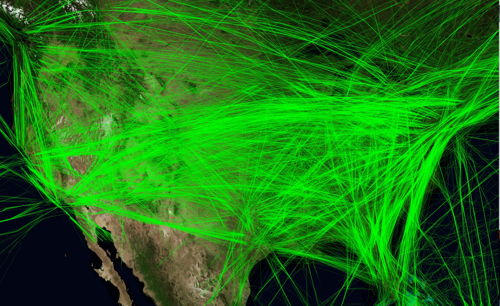
Lot's of flyover traffic in the south of the UK: Notice all the tracks that start/stop over the channel to/from Heathrow.
WeedWhacker
Senior Member
Ok guys my next question is what about the near perfect grids or "tic tac toe" patterns? Wouldn't they tend to follow the same paths?
"Contrail Science" explains that well, too.
Now, just to help, consider the map of any country and the ways that routes (in the air) between various cities require airplanes to fly different courses over the ground. Also, a street map is an analogy too, although limited.
When at "Contrail Science" you will find this:
http://contrailscience.com/contrail-simulations/
Think of this: A route flown by multiple airplanes (just one ROUTE, for now) will be a track over the ground, and in reference to ground-based coordinates.
This "same" ground track, flown by airplanes in multiple succession, who ALL make a contrail. Now....the contrails themselves (just clouds, after all) will "drift" with whatever prevailing winds aloft exist.
Complicate it by adding other High Altitude Jet Airway routes that intersect the ones previously mentioned. Sometimes, even at right angles.
Don't know where "you" are specifically located, but check this example (and use the site to find your location, and learn more):
http://skyvector.com/?ll=36.08018187965441,-115.15209960856069&chart=304&zoom=3
jtmac
New Member
Ok thanks I willBut also look at the south of UK image above. As well as the wind blowing trails from the same routes, there are lots of planes flying parallel routes.
WeedWhacker
Senior Member
Ok thanks I will
I do hope this info helps. Short of taking a ton of flying lessons (also a suggestion...kidding, but only slightly), there can be learned a lot here, and at Contrail Science (and elsewhere). (Thumbs Up!)
WeedWhacker
Senior Member
Ya that link is like chinese to me. Way over my head.
Sorry....the one I gave you to "SkyVector"?
Again, sorry. If you go back and take a bit of time, you can actually find that every Aviation Chart that is hosted by that site includes an index to help interpret.
And yes....if new to aviation, the way that aeronautical charts are presented can seem a bit "intimidating", at first. But, think of it as learning a new 'language' ( except, it's actually easier!!
") )
)(Please don't hesitate to ask questions. I'm free...)
WeedWhacker
Senior Member
Ya skyvector. I will look into it more.
Please do. And, as I said....am happy to help with any questions. You can send a Private Message ('PM') so as not to clutter the thread.
I was a Flight Instructor for some years, and then a commercial airline pilot for a few decades. There are other pilots here, as well. I think any of them will be happy to assist.
deirdre
Senior Member.
I cant figure out flight aware, either. I look at flight radar, but you have to kinda guess distance from yourself. http://www.flightradar24.comYa skyvector. I will look into it more.
They do have a distance scale on the map.I cant figure out flight aware, either. I look at flight radar, but you have to kinda guess distance from yourself. http://www.flightradar24.com
deirdre
Senior Member.
thanks. I meant how far to look regarding where the contrail might be, which plane path. as above you said it could be 100 miles away even though it looks like right over head. so people might think there's no flights right over head, so must be covert operations.They do have a distance scale on the map.
I cant believe you got a screen shot of LA with only 2 planes showing!
WeedWhacker
Senior Member
I cant figure out flight aware, either. I look at flight radar, but you have to kinda guess distance from yourself. http://www.flightradar24.com
PM to me.
Be happy to help
thanks. I meant how far to look regarding where the contrail might be, which plane path. as above you said it could be 100 miles away even though it looks like right over head. so people might think there's no flights right over head, so must be covert operations.
I cant believe you got a screen shot of LA with only 2 planes showing!
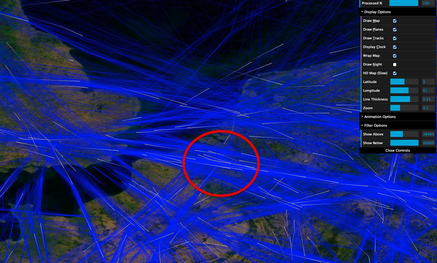
It's filtered for above 28,000 feet, only flyover traffic.
deirdre
Senior Member.
ah. that's a good tip. wouldn't have thought of that.It's filtered for above 28,000 feet, only flyover traffic.
Tyrrellica
New Member
Greetings, hope all is well.
I am posting this question to the community here, in hopes that someone of the 'higher primate' variety can help me combat the uninformed and what is being deemed as "Chemtrail Proof". This video is being shared on FB via Chemtrail Research and I am constantly defending what I honestly believe are Contrails to the likes of these clowns. I was sent this link, and basically told "Are you saying these are not real?" Is there a way to explain this, easily, to someone who has drank the chemical kool-aid? I apologize in advance if this is the wrong thread, I just got a bit worked up over defending what I deem as either a doctored video or just a lot of air traffic over a clear day. The post/video is here:
https://www.facebook.com/chemtrailresearch?fref=photo
under the heading "Wake the F up!"
Thanks in advance, so glad to have found this site!
I've merged in the above post, as the image in the OP seems to come from the referenced video:
Sounds like the person videoing says "Ja, Und dis ist ichnuch normal?" - what language is it? German?
Identifying the original video would be helpfull to fully explain it.
Sounds like the person videoing says "Ja, Und dis ist ichnuch normal?" - what language is it? German?
Identifying the original video would be helpfull to fully explain it.
Last edited:
JFDee
Senior Member.
Sounds like Dutch, that sentence being very close to German, translating to: "Yes, and this is really not normal".what language is it? German?
Can't understand the rest of it.
Addendum: the style of the visible roofs matches that of Central Europe.
Last edited:
Miss VocalCord
Senior Member.
I've merged in the above post, as the image in the OP seems to come from the referenced video:
Sounds like the person videoing says "Ja, Und dis ist ichnuch normal?" - what language is it? German?
Identifying the original video would be helpfull to fully explain it.
It sounds like Flemish/Belgian Dutch to me, so I have to be a little carefull with translating it since there are some differences between 'normal' Dutch. I would say this is filmed in Belgium therefore.
It is a very rough translation, but I guess it covers it pretty much ( I think the first sentence is meant to be sarcastic)
"Yeah, because these are really normal" --- ("Ja want deze is echt nog normaal")
"Just look at the bends and curves" --- (Kijk gewoon al naar de bochten en curven")
"Isn't normal anymore.." --- ("Is niet meer normaal")
"They are just big.... --- ("Zijn gewoon grote")
(mumbling in the background I can't make out either)
I think this is the same video on youtube (but with 'music')
The poster says it is near Brussels in Belgium in on of the comments
Last edited:
This channels has many similar videos, and seems to be the same location [Edit: although the houses look different]
https://www.youtube.com/channel/UCyTmKGcfoDidOlxPQUGJDsg/videos
Most of the videos have far fewer contrails.
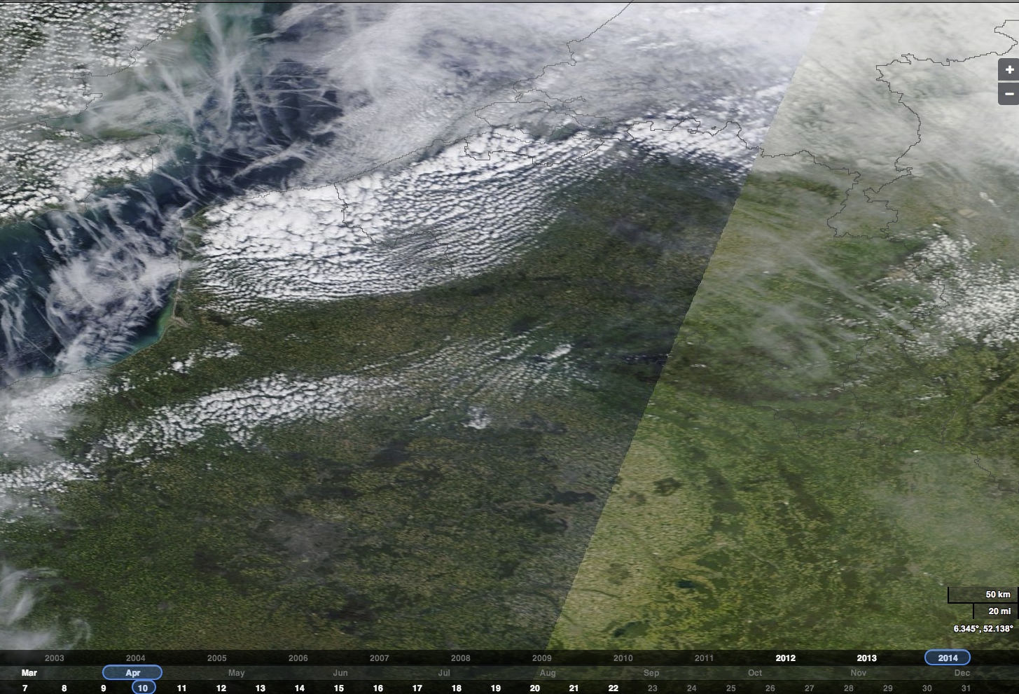
The April 10th video is similar to the OP:
Satellite image for that day shows lots of contrails in the region
https://earthdata.nasa.gov/labs/wor...10&map=-0.994141,47.844727,6.894043,52.432617
https://www.youtube.com/channel/UCyTmKGcfoDidOlxPQUGJDsg/videos
Most of the videos have far fewer contrails.
The April 10th video is similar to the OP:
Satellite image for that day shows lots of contrails in the region
https://earthdata.nasa.gov/labs/wor...10&map=-0.994141,47.844727,6.894043,52.432617
Last edited:
Miss VocalCord
Senior Member.
This channels has many similar videos, and seems to be the same location [Edit: although the houses look different]
I think this is the original upload to facebook by Nani Dub S Munroe. It is said to be filmed at Brussel - Dworp:
http://goo.gl/maps/4uZFh
Where you can find such houses
Last edited:
Lobster Johnson
Member
It's important to realize that when you see contrails, they are not being formed by the traffic locally arriving/departing at an airport near you.
This is 'flyover" traffic.
If you look at this link:
http://skyvector.com/?ll=53.57456921174049,-0.3510131811667493&chart=304&zoom=4
You will see a Chart of the normal High Enroute Airways, with Humberside centered. Then, you can manipulate the "map" as usual (same as with Google maps, for instance).
I never know that! I just always assumed it was from planes diverging out from there but I see that makes far more sense and would explain the criss cross. So if that's the case then could jtmac's pattern happen anywhere that is on a flightpath?
Hama Neggs
Senior Member.
I never know that! I just always assumed it was from planes diverging out from there but I see that makes far more sense and would explain the criss cross. So if that's the case then could jtmac's pattern happen anywhere that is on a flightpath?
His image seems to show more than one intersecting flight corridor. Not that unusual, though, given the large number of corridors and flights in general.
Similar threads
- Replies
- 5
- Views
- 335
- Replies
- 3
- Views
- 2K