Invisibility cloaked jet?

fizzBuzz

Active Member
So I saw this tweet:

Source: https://twitter.com/iluminatibot/status/1755305484565852513


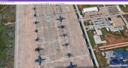
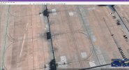
And decided to look at it myself. It's located at the Dyess Air Force Base in Abilene, Texas: 32.414360, -99.844289

There definitely appears to be some sort of light refraction going on, just based on the concrete tiling below the object.

cloaked airplane.png

And Google Earth seems to think there is a "plane" shaped object there which has a very similar shape to the other "non-cloaked" plane.
cloaked airplane 3d.png

Has anyone seen this before? What could this be? Could this just have been a manual(or automated) edit to the image to removed a plane?
 
What doesn't make sense is that the object doesn't cast a shadow. If this was in fact a "invisibility cloaked" jet, it would still cast a shadow. Even if it was glass, there would still be a faint shadow and perhaps a caustic effect on the ground.
 
Last edited:
The same distortions are over other objects and shadows, just some weird artifact or AI imaging.

The plane just looks like a mirror of the other B1 bomber, you can also see the same stuff under it.
 
There's nothing even remotely mysterious about it.

The original ( non 3D ) overhead image is likely little more than the shape of the plane being left behind in the dust after a heavy rain storm washed the surrounding dirt away. Or it could be some chemical ( de-icing fluid ) sprayed on the plane that has dripped onto the ground.

The 3D image is nothing more than an artefact of the Google Earth 3D generator thinking its a solid object and rendering it such. It's not actually 'there'...it is AI generated.
 
Could it be that the google earth photo was taken as the plane was being moved inside a hangar? Weird effects can be obtained when imaging something in motion.
 
Image processing artifact.

A 2D image is being draped over a 3D elevation model.
When the 3D model was created there was a aircraft sitting there, so the digital elevation preserves that fact.
As far as GE is concerned there is an aircraft shaped "hill" in the middle of that parking apron.
As you ask GE to show you the area from an oblique perspective, instead of vertical, it is trying to stretch the images it has available to reflect that bomber shaped hill.
 
The 3D image is nothing more than an artefact of the Google Earth 3D generator thinking its a solid object and rendering it such. It's not actually 'there'...it is AI generated.

I was thinking that the sources of the 3D data and the photography are different, i.e. there was an aircraft there when the 3D scan was made, but not when the image was taken?
 
There's nothing even remotely mysterious about it.

The original ( non 3D ) overhead image is likely little more than the shape of the plane being left behind in the dust after a heavy rain storm washed the surrounding dirt away. Or it could be some chemical ( de-icing fluid ) sprayed on the plane that has dripped onto the ground.

The 3D image is nothing more than an artefact of the Google Earth 3D generator thinking its a solid object and rendering it such. It's not actually 'there'...it is AI generated.

I expected more from an account called illuminatibot.
 
I expected more from an account called illuminatibot.
The vast majority of links posted by that account point to thepeoplesvoice.tv, which is a well-known fake news site (formerly known as NewsPunch). I strongly suspect that the account is affiliated to that site.

Regarding the image, I think it is pretty clear that it is an artifact. The imagery was captured when there was no plane, but the LIDAR 3D data was captured when there was a plane. So you get a "phantom plane" effect, as @Mendel and @MapperGuy said above.

Edit: the 3D data is from photogrammetry, not LIDAR.
 
Last edited:
The vast majority of links posted by that account point to thepeoplesvoice.tv, which is a well-known fake news site (formerly known as NewsPunch). I strongly suspect that the account is affiliated to that site.

Regarding the image, I think it is pretty clear that it is an artifact. The imagery was captured when there was no plane, but the LIDAR 3D data was captured when there was a plane. So you get a "phantom plane" effect, as @Mendel and @MapperGuy said above.
It's a bit dis-heartening seeing some of the stuff that is thrown around, even more so is the support it gets. The reaction to Sean Kirkpatrick's recent statements are a great example, then there is the accusations of anyone with a skeptical opinion as being dis-info agents, psyops etc.
 
Image processing artifact.

A 2D image is being draped over a 3D elevation model.
When the 3D model was created there was a aircraft sitting there, so the digital elevation preserves that fact.
As far as GE is concerned there is an aircraft shaped "hill" in the middle of that parking apron.
As you ask GE to show you the area from an oblique perspective, instead of vertical, it is trying to stretch the images it has available to reflect that bomber shaped hill.
This makes sense.

I wonder if there are more instances of this at other airports on Google maps. It's certainly a coincidence that it happened at an Air Force base lol Though it could be a common thing in Google maps, just not noticeable. Or no one cares when it's not on an Air Force base.
 
Whatever system Google Maps/Earth uses to create the 2D and 3D imagery doesn't align very well with moving objects. You get weird things like empty container terminals, trains tens of miles long, and mostly invisible vehicles.

Either that or DC Metro is experimenting with extremely long stealth trains and their employees are driving cloaked SUVs.
metro.JPG
 
I always thought most (google) topography maps were made by using photogrammetry techniques.
 
I'm pretty sure Google Earth and Google Maps don't use lidar other than in Street View, based on Google Earth Help: How images are collected, documentation such as Google Earth Studio: Introduction and semi-official responses to questions like this: does Google Earth have lidar images? If you have lidar data from another source, you can add it as an overlay from sources such as Earth Engine Data Catalog.

Most of the Google terrain images are mosaics from multiple image from multiple sources often taken at different times of day and seasons, so there's a lot of scope for glitching.

Google does say their mapping relies on photogrammetry.
 
I've been on the flight line at Dyess, I never saw any invisible a/c.

I do know it didn't used to be uncommon for images/messages to be illustrated/painted on airbases for the express purpose of being seen/read by satellites passing overhead. Some were done unofficially, like the message in Chinese I saw on the roof of a hanger I was told was encouraging them to perform a sexual act I'm pretty sure is impossible.

At a remote facility, however, I saw some very unusual illustrations on the tarmac near a maintenance hanger. When I (stupidly) asked what they were, all I was told there were there to spoof overhead surveillance. Considering we got a daily "bus schedule" briefing on when and whose satellites would be over the facility, they certainly knew what nations they were messing with. This was over 30 years ago, so I don't know if such things are still done or how effective it was at the time.

I'm not suggesting that's what we see in the Google Earth image, just that I've seen some unexpected images on airbases meant to be seen by satellites.
 
I'm pretty sure Google Earth and Google Maps don't use lidar other than in Street View
Article:
Jul 31, 2010
One of my favorite features in Google Maps is the terrain layer, which provides a shaded relief (aka hillshade) view of the topography derived from a digital elevation model. Google has done a nice job generating a visually pleasing terrain layer, and we use it for all of our Google Maps-based interfaces in OpenTopography. Google appears to use a range of digital elevation model data sources to derive the terrain layer. Throughout the US, it appears that the terrain layer comes from either 10 or 30 m (1/3 arc-second & 1 arc-second respectively) DEMs from the USGS National Elevation Dataset (NED). Globally the terrain data appear to be derived from either Shuttle Radar Topography Mission (SRTM) data or something like the NOAA Global Land One-km Base Elevation Project (GLOBE) dataset. Recently however, I've begun to notice higher resolution data in the Google Maps terrain layer. These higher-resolution data are localized, and are patched into the terrain layer among the standard 10 and 30 m derived images, but they are impressive when you find them. Based on the location of these patches of high-resolution terrain, and their appearance, it is pretty easy to deduce that Google is now incorporating bare earth LiDAR digital elevation models into the Google Maps terrain layer.
 
I've been on the flight line at Dyess, I never saw any invisible a/c.

I do know it didn't used to be uncommon for images/messages to be illustrated/painted on airbases for the express purpose of being seen/read by satellites passing overhead. Some were done unofficially, like the message in Chinese I saw on the roof of a hanger I was told was encouraging them to perform a sexual act I'm pretty sure is impossible.

At a remote facility, however, I saw some very unusual illustrations on the tarmac near a maintenance hanger. When I (stupidly) asked what they were, all I was told there were there to spoof overhead surveillance. Considering we got a daily "bus schedule" briefing on when and whose satellites would be over the facility, they certainly knew what nations they were messing with. This was over 30 years ago, so I don't know if such things are still done or how effective it was at the time.

I'm not suggesting that's what we see in the Google Earth image, just that I've seen some unexpected images on airbases meant to be seen by satellites.
Russians have recently painted fake aircrafts on the tarmac of their airports:

Satellite imagery shows Russia is now painting the silhouettes of Tu-95MS “Bear-H” strategic bombers in parking revetments at its master bomber base, Engels Air Base, also known as Engels-2. The base has come under repeated attack over the last year and as Ukraine's standoff weapons capabilities are rapidly evolving, so are its abilities to strike deep inside Russia using local sabotage and drone attack teams.
Content from External Source
https://www.twz.com/tu-95-decoys-are-being-painted-on-russian-air-bases-apron

(Sorry for not posting the pictures too but they are all copyrighted)
 
I think there's good reason for disciplinary action, maybe a court martial, on show here.

Some crafty member of groundcrew has clearly "appropriated" some of the ultra-secret invisibility paint to touch up the paintwork on one of the wheels of his trailer (or whatever it is).

cloaked airplane 3d.png
 
Just going to "ground view" and wandering around the area should disabuse anybody of the notion that the 3-D renders are flawless representations of reality.
under noc=se of invisible plane.JPG
The interesting piece of modern art in the center there appears, from other angles, to be in reality a rolling ladder/staircase.


other view.JPG
View from a nearby parking lot looking back toward the hangers and airfield. If THAT is an accurate image, an invisible plane is perhaps the LEAST interesting thing going on there.
 
If THAT is an accurate image, an invisible plane is perhaps the LEAST interesting thing going on there.

@JMartJr, I didn't think this day would come, but through your investigations you might have revealed The Truth about the USAF having secret craft of alien origin...

I guess we just have to accept that Messrs. Lazar, Elizondo, Grusch etc. were right all along.

Oh dear..jpg


"Jellyfish" UAP, Iraq:
see Metabunk thread "Jellyfish UFO from TMZ's 'UFO Revolution'" (link here)

Nemo from Walt Disney's "Finding Nemo": Wikipedia, "Finding Nemo"

"Best ever" UAP, Ecuador:
see MB thread "Claim: ''UAP researcher'' released clear smoking gun photo of Orb captured by photographer" (link here)

What have you done, JMartJr? What have you done?!
 
If THAT is an accurate image, an invisible plane is perhaps the LEAST interesting thing going on there.
Google Earth is a wonderful and useful tool. But like all tools it has its limits.

The invisible airplane is an excellent example of one of its limits. Unfortunately too many people watching CSI:whatever TV shows think you can just zoom-in forever and obtain more and more information.

In this case the DEM (Digital Elevation Model) being used for this location and level of zoom has an error. I have no idea the source of the DEMs they are using, but they are probably not updated as often as the photos being draped over them. The shape of the world does not change as rapidly as the things sitting on its surface change. Perhaps someone from Google will notice the original post on Twitter and make a correction to the DEM, or maybe they are regularly updated.
 
I've been on the flight line at Dyess, I never saw any invisible a/c.

I do know it didn't used to be uncommon for images/messages to be illustrated/painted on airbases for the express purpose of being seen/read by satellites passing overhead. Some were done unofficially, like the message in Chinese I saw on the roof of a hanger I was told was encouraging them to perform a sexual act I'm pretty sure is impossible.

At a remote facility, however, I saw some very unusual illustrations on the tarmac near a maintenance hanger. When I (stupidly) asked what they were, all I was told there were there to spoof overhead surveillance. Considering we got a daily "bus schedule" briefing on when and whose satellites would be over the facility, they certainly knew what nations they were messing with. This was over 30 years ago, so I don't know if such things are still done or how effective it was at the time.

I'm not suggesting that's what we see in the Google Earth image, just that I've seen some unexpected images on airbases meant to be seen by satellites.
I have been advocating for more humorous DISO measures, this is now another good example.

And yeah, those are still done, the effectiveness of it is comparatively hard to assess, definitely not what's happening in this case though, unless you're using things like SAR bands they tend to look like this;
View attachment tu-95-decoys-are-being-painted-on-russian-air-bases-apron-v0-njiEYzdRLo_BaosTzeR-5RD_ar4Ibarm...webp
View attachment 659c52456979d73718216722.webp
View attachment 659c6be06979d737182173c5.webp

This is really only effective for normal pictures though, if you use stuff like SAR, it won't reflect right (even if its reflective paint), and the reflective paint is better for mobile/in maneuver equipment since it can assist in further obfuscating signatures, but if stationary it will consistently appear incongruent from the actual planes in this case.
There's some other things used now in this context too like purpose built decoys, but they're pretty expensive to build ones capable of mitigating risks to actual military/gov technology. We only made like half a dozen actual purpose built decoy HIMARs for Ukraine, as an example, the rest were shoddy wooden decoys and repackaged equipment they did themselves.
 
And yeah, those are still done, the effectiveness of it is comparatively hard to assess, definitely not what's happening in this case though, unless you're using things like SAR bands they tend to look like this;
View attachment tu-95-decoys-are-being-painted-on-russian-air-bases-apron-v0-njiEYzdRLo_BaosTzeR-5RD_ar4Ibarm...webp
View attachment 659c52456979d73718216722.webp
View attachment 659c6be06979d737182173c5.webp
Your images:


(The forum software doesn't do webp properly. The trick is to take the attachment link and insert it as an image.)
 
I'm pretty sure Google Earth and Google Maps don't use lidar other than in Street View,
Looks like this is correct - it's not LIDAR but high-resolution photogrammetry from low-altitude aerial photography.

There's a good explainer in this video:


Presumably the 3D imagery only gets done once for a given area as it is an intensive process, so if the photography gets updated later then you get newer images draped over the older mesh.
 
Last edited:
Almost all of England and Wales has been scanned with lidar, and it has provided an invaluable resource for finding archaeological sites for which no structure remains above ground. Such things as Neolithic barrows, appearing to be plowed flat to the untrained viewer standing at ground level, can clearly be seen.
The LIDAR Composite DTM (Digital Terrain Model) is a raster elevation model covering ~99% of England at 1m spatial resolution. The DTM (Digital Terrain Model) is produced from the last or only laser pulse returned to the sensor. We remove surface objects from the Digital Surface Model (DSM), using bespoke algorithms and manual editing of the data, to produce a terrain model of just the surface.
Content from External Source
https://environment.data.gov.uk/dataset/13787b9a-26a4-4775-8523-806d13af58fc
 
Some LIDAR is used.
https://developers.google.com/earth-engine/datasets/tags/lidar
Datasets tagged lidar in Earth Engine
• AHN Netherlands 0.5m DEM, Non-Interpolated
• Australian 5M DEM
• England 1m Composite DTM/DSM (Environment Agency)
Content from External Source
Those are third-party datasets available to use as overlays; that doesn't mean Google uses them to generate 3D imagery.

I also suspect Google isn't paying civilian lidar firms to overfly military bases to get detailed point clouds of their facilities.
 
It makes me wonder how much more stealthy it'd make an aircraft on top of what is already considered stealth.

Surely radar lets you down before being visible to eyes does?

If so, what tactical advantage is there?

Not saying the tech doesn't exist, just I doubt you'd put it on that/a plane. And I'm assuming perfect radar invisibility hasn't been achieved yet.
 
Last edited:
There are other ghost images/distortions in the same area /set of images.
32.4279696880623, -99.84711223996383
Screenshot 2024-02-09 at 20.30.19.png

32.431480109629796, -99.85051776456241
Screenshot 2024-02-09 at 20.31.02.png
and a couple of ghost passenger planes ready for boarding at London Heathrow
51.47149114186121, -0.4823949425777063
Screenshot 2024-02-09 at 20.53.56.png
 
Last edited:
There's nothing even remotely mysterious about it.

The original ( non 3D ) overhead image is likely little more than the shape of the plane being left behind in the dust after a heavy rain storm washed the surrounding dirt away. Or it could be some chemical ( de-icing fluid ) sprayed on the plane that has dripped onto the ground.

The 3D image is nothing more than an artefact of the Google Earth 3D generator thinking its a solid object and rendering it such. It's not actually 'there'...it is AI generated.

It seems some doubt doubt my notion that the 'cloaked aircraft' is simply dust/residue on the runway. Well.....I can do no better than say, look at the numerous other examples from the same airport.....where clearly the aircraft regularly get parked in exactly the same place again and again....especially in the second example where you can very clearly see the same sort of light grey outline of a plane....
 

Attachments

  • planes.jpg
    planes.jpg
    305.5 KB · Views: 13
  • planes2.jpg
    planes2.jpg
    249.4 KB · Views: 14
Last edited:
It seems some doubt doubt my notion that the 'cloaked aircraft' is simply dust/residue on the runway.
We don't doubt there's stains on the apron (most runways are kept clear of parked aircraft).
We doubt that Google employs AI to elevate these stains into 3D models of aircraft.

The idea that Google collected 3D data from actual aircraft and then changed the textures when a new set of imagery was added (but kept the 3D data) seems to require fewer unknown steps not in evidence.

You're also going to have a hard time extending your "stains" hypothesis to @Alexandria Nick 's DC Metro screenshots in post #12 above.
 
We doubt that Google employs AI to elevate these stains into 3D models of aircraft.

The idea that Google collected 3D data from actual aircraft and then changed the textures when a new set of imagery was added (but kept the 3D data) seems to require fewer unknown steps not in evidence.

But in the case of the alleged 3D aircraft there quite clearly is a stain on the ground. In fact I suspect there are two. The 3D software then simply mistakes the lowermost stain for a shadow, which I suspect is one of the criteria for making something 3D.
 
51.47149114186121, -0.4823949425777063
In fact it's clear that in this example the whole plane area has been rubberstamp photoshopped from one gate to another so that the airport is shown without planes in the gates. So these maps are clearly manipulated for various aesthetic reasons. (Yet they don't do this with all airports. Chicago O'Hare 41.97758162964252, -87.90358373717412 for example).
So in the example in #1 is it not likely that there was a plane there which has been erroneously been given the texture of the ground?
 
Last edited:
But in the case of the alleged 3D aircraft there quite clearly is a stain on the ground. In fact I suspect there are two.
Yes. Because habitually, aircraft are parked there. Which is why there is 3D data for an aircraft in that location in the first place.
The 3D software then simply mistakes the lowermost stain for a shadow, which I suspect is one of the criteria for making something 3D.
There is no evidence that Google uses technology like that, and that this technology would make those kinds of mistakes.
In fact, if you ask AI image generators for aircraft, none of them are ground-textured. Your hypothetical AI knows enough about aircraft to get the correct shape from no more than a vague stain on the ground, but fails to apply a plausible texture?
 
But in the case of the alleged 3D aircraft there quite clearly is a stain on the ground. In fact I suspect there are two. The 3D software then simply mistakes the lowermost stain for a shadow, which I suspect is one of the criteria for making something 3D.

The process being used by Google Earth to produce the 3D views is not as complicated as you might think. It is simply taking a 2D photograph taken looking vertically and projecting it onto a 3D surface. Then showing you that 3D surface, with the picture draped over it, from different angles. The 2D image is not being analyzed or edited, the system has no idea what real world objects it is showing, it just knows patches of color and where on the Earths surface they are. It is a "dumb" system displaying truly massive amounts of data.
 
Actually I think Scaramanga is correct

Its not using any height data from lidar or whatever, its just 'guessing' a height mesh from 2d images.
Thus it could of seen these stains and its algorithm thought Oh that looks like a plane thus lets create a plane heightmesh here
 
Back
Top