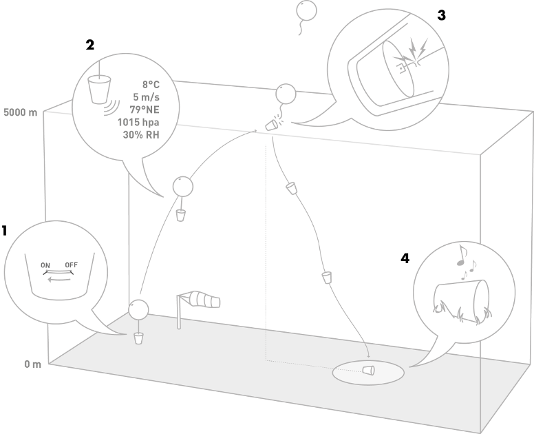
Windsond is a weather balloon system for an immediate view of local conditions at different altitudes. The focus on portability and low operating costs makes it perfect for frequent use in the field.
And if you live in an area with military activity then you'll probably see plenty of trails from untracked planes. The racetrack loop you mention sounds like it could well be one of those.
Sometimes the contractors to the military show up. During the week this area is void of commercial traffic. China Lake Naval Air Weapons Station and Edwards Air Force Base use this air space for practice. A buddy of mine has some property below this race track. Looks like he is getting a good show from some fighter jets today.
I am having trouble Id'ing a jet on flightradar24! Can anyone help? The flight was 6th Dec at approx 12:30pm S.W. Of San Jose. 4 engines. It's not my photo and I Have asked they check the time stamp.... Will be back to provide the link as I don't know how to work this iPad! Can't find how to copy paste!!!
I am having trouble Id'ing a jet on flightradar24! Can anyone help? The flight was 6th Dec at approx 12:30pm S.W. Of San Jose. 4 engines. It's not my photo and I Have asked they check the time stamp.... Will be back to provide the link as I don't know how to work this iPad! Can't find how to copy paste!!!
The simplest way to remember is "America, add" - times in the Americas are earlier than GMT/UTC, so you have to add hours to get the universal time used by plane finders. Times in most of the rest of the world are later than GMT/UTC, so you have to take off hours.
The simplest way to remember is "America, add" - times in the Americas are earlier than GMT/UTC, so you have to add hours to get the universal time used by plane finders. Times in most of the rest of the world are later than GMT/UTC, so you have to take off hours.
To be failsafe I always ask google, "[time] [location] in UTC"
[ATTACH=full]23260[/ATTACH]
Check the day of the week, as it might be the next day. If it's PM make sure you add 12 (8PM -> 20hrs)[/time]
Thanks for the help. I am lost without my computer (it died) and favourite links and am useless on the borrowed iPad even with googles help.
I think it is the flight just before the one above AAR201 as the livery appears dark blue . I can't print screen can someone please put that flight up and a shot of the link below showing the livery. The original photo is on a chemtrail page and I asked the guy if he had details of the flight. He didn't but was happy for me to help.
Are you talking about the same plane as in your above post? AAR201 (another A380 on the same route) passed by San Jose on December 6 at about 20:10 UTC (1:10 PM local time). Can you give us a link to the original photo, or is it on a private page?
Are you talking about the same plane as in your above post? AAR201 (another A380 on the same route) passed by San Jose on December 6 at about 20:10 UTC (1:10 PM local time). Can you give us a link to the original photo, or is it on a private page?
Thanks. Here is a crop of the full-size image:
The plane is backlit and hardly discernible against the sky, but the pane's belly does look darker than the underside of the wing, which is consistent with the Asiana Airlines livery. Otherwise, the illumination of the plane and its contrail is consistent with the flight route and the sun position at the time for both AAR201 and KAL18.
The plane is backlit and hardly discernible against the sky, but the pane's belly does look darker than the underside of the wing, which is consistent with the Asiana Airlines livery. Otherwise, the illumination of the plane and its contrail is consistent with the flight route and the sun position at the time for both AAR201 and KAL18.