You mean for making a screenshot? I usually put it on full screen, start it playing seven or eight seconds before the shot I want, and by the time it gets there the title has disappeared and I can screenshot it while it's in motion.
Some perspective here, as they might actually use these numbers for something. Those power ratings are vastly inflated. I have the same laser that they say is 10,000mW. It's a generic Chinese 303 laser.
It's marked on the laser itself as <1000mW
And even that is a great exaggeration, it's probably under 200mW. By comparison, a presentation laser pointer (like the one I use in some demonstrations) is <5mW.
It's also generally sold for $10 to $20, so they are getting ripped off paying £60. Similarly with the other laser and the torch/flashlight
That said, it's quite adequate for the task of being visible over ten miles. I bring it up in part because making claims about the power, professional nature, and even the cost of equipment is sometimes used to give an air of authority to the proceedings.
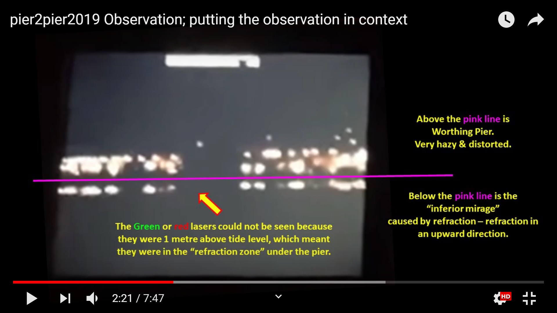
I don't know if he is claiming a small victory as they could then see the green laser by moving up the beach, gaining some extra height. No mention of the red laser. seems they ended up being much higher than the original setup, ie just 1 meter above water level, so a small green dot was seen. if they BOTH moved up that changes the height to a level where both parties are not hidden by the bulge.
He is apologizing for not livestreaming the event; even though refraction made the experiment as planned impossible. They moved up the beach just to see what they could learn. As soon as the camera moved above the refraction zone, the laser appeared as expected. I don't know if he considers this a small victory, or just an "of course" sort of thing. That this is in line with what would be expected on a SE is not mentioned.
RE: The Refraction Zone.
It is a well established bit of FE lore that there is a zone in between the upright and inverted image in an inferior mirage in which things are hidden which would normally be visible (on the Flat Earth). Globe Heads have mistaken this for obscuration due to a curve.
This goes back to at least Sept. of 2016. Some folks here might remember Sandor Szekely and the Lake Balaton Laser Experiment. The concept of the NUDTZ - the Non-Uniform Density Transition Zone - was invented at that time.
The importance of NUDTZ is in the video at around 20 min they just refer to this undescribed and imaginary "scientific phenomena" as something proven, to explain why their ship started to disappear from bottom up...
A wikipedia page was created to establish a (self) reference for this new concept. The page was deleted.
Dr. John D. is presenting the refraction zone effect as established scientific fact.
Here he is explaining that the laser is in that zone of invisibility - between the upright and inverted images.
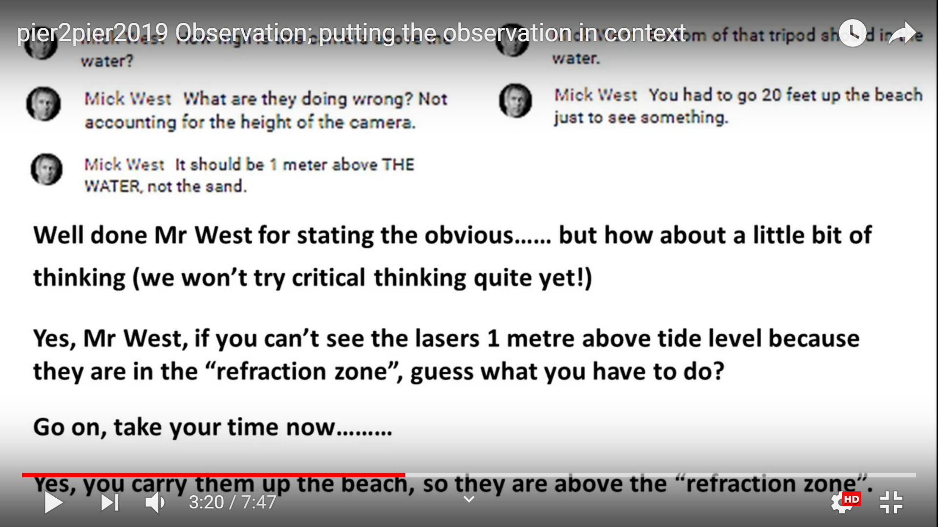
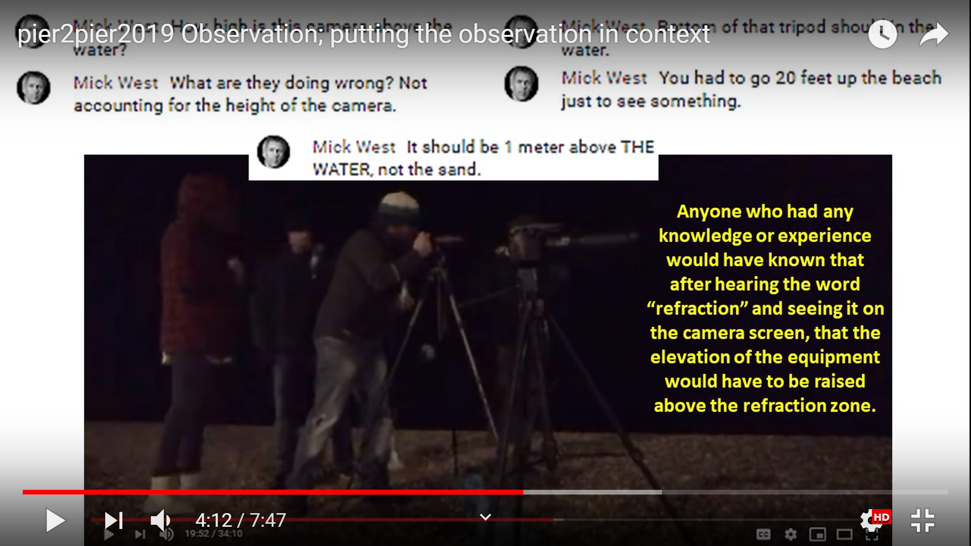
Here he is chiding people, specifically MW, for ignoring the established effects of the Refraction Zone.
"The elevation of the refraction zone was decreasing" as the night went on and the laser would have become visible to a camera 1 meter above the water surface eventually, but everyone had to go home.
He concludes:
If by some fluke the laser is visible at that time it will be absolute proof of FE. It could not be explained by looming or ducting, because light does not bend downwards in the atmosphere. A scientific fact established by Dr. John D.
Low tides at Newhaven are at 19:32 (Fri), 7:52 and 20:15 (Sat) (NTSLF prediction).
I would assume a two-hour interval around those times would be good for low tide observations. https://tides4fishing.com/uk/england/brighton also has short-term weather and water temperature predictions.
Sunset is at 17:30, sunrise is at 7:00.
Therefore, the Saturday morning observation should be at daylight.
@Z.W. Wolf The inferior mirage itself hides things, why would they need to invent another refraction zone?
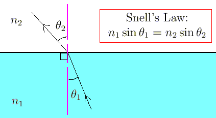
I think it's partly because of they understand refraction only in terms of Snell's law, which is the change in angle of a beam as it goes from one medium to another, like:
Hence they feel like there needs to be some kind of boundary between regions. They don't get the concept of a gradient index. Which is partly why I was spurred to do the simulator and fishtank demonstrations.
don't laugh.. what about something like a tequila sunrise. can you layer a tall glass with liquids of different densities that would demonstrate what is meant by a gradient? obviously in that example the gradient could only go from lighter to denser because a liquid filled glass isnt the atmosphere...
(if this idea will confuse them more, then you can delete this comment )
If I refill the tank, I might try using a slightly yellow solution on the bottom. The way to do it is to pre-mix the sugar as a simple syrup, color it, partly fill the tank with pure water, and then add the syrup to the bottom using a funnel.
to how my brain pictures things, that still implies that there are precise layers/zones. my sandart beaker is 10 miles wide. (not that there is a huge refraction difference if the water over the middle of the sea is colder..as far as Dr. J's last experiment.. but i'm just trying to help others visualize.)
I just did a google search for thermal gliding , and found pictures like these:
and when I use wind thermal coastal seaward, I find
Note that the sea breeze is landward during the day, at least in summer. The diagonals in the bottom diagram reverse their slopes in the morning and in the evening, at least in theory.
"Line" is better terminology, although "Non-Uniform Density Transition Zone" is still meaningless. Here's the dividing line
What it is really is a "critical angle" below which there's a total internal reflection, but these reflections are occurring at a variety of altitudes and distances and refractive indices.
What it is really is a "critical angle" below which there's a total internal reflection, but these reflections are occurring at a variety of altitudes and distances and refractive indices.
No, it's going to be warmer, 7°C to 11°C, according to Weather.com's 10-day forecast. This will match very well with the water temperature, which will be around 8°C. So very good conditions overall, for avoiding mirages.
However, it does not take much at all to pop a laser over the horizon. Hopefully with all the other lights then any refraction should be somewhat apparent. The problem is going to be when they go down to 3ft above sea level. If it's dark, then the refraction will be hard to determine.
It's all pretty ridiculous. Someone can just pop down there in the daytime and take a photo of the pier. John has already got lots of photos that show the curve obscuring the Brighton beach from Worthing.
As discussed in the OP. This new test adds nothing except the potential of hard to interpret results with an out of context laser dot.
What it is really is a "critical angle" below which there's a total internal reflection, but these reflections are occurring at a variety of altitudes and distances and refractive indices.
The red line (the "mirror") is convex, and like a convex mirror, compresses the image. Is this line straight in your flat Earth refraction model, i.e. is this a way to prove the globe?
that actually at least makes sense. if the bendy light makes the earth look like a globe during the day (which it does), then without the light it would be a plane.
The red line (the "mirror") is convex, and like a convex mirror, compresses the image. Is this line straight in your flat Earth refraction model, i.e. is this a way to prove the globe?
Kind of. On a flat earth an inferior mirage has a lot less distortion and goes all the way down to where the gradient is steepest. So the amount that's hidden in reality is a good indicator. Compare these. Flat first:
Exact same view on the globe:
Notice:
A) the wooden pier structure is missing.
B) The inverted image is compressed.
He is right next to one of the most busiest shipping lanes in Europe, perfect opportunity to see large ships going and appearing over the horizon, or seeing if he can see France. It seems that a lot of time and effort is spent presenting what they think they should not be able to see, whereas they should be asking why they are not seeing what they should be able to see. After all, Isle of Man from Cleveleys at 65 miles, Pic Gaspard in the hundreds miles can be seen in the right conditions. So why not France from the south coast, or even Belgium or Holland (the low countries).
However, it is good for him to be trying this in as many conditions as he can...build up the data. Just hope he learns something from all of it.
You can't learn from that experiment because it is not answering a useful question.
Can we see a light although we should not? Yes, because of refraction.
Can we not see a light, although we should? Yes, because of refraction.
The question that Flat Earth needs to be asking on this is,
a) how does air pressure affect refraction,
b) does the refraction we observe bend the light up or down?
Repeating an observation that you know can't decide your question is just cargo cult science (Feynman).
The question that Flat Earth needs to be asking on this is,
a) how does air pressure affect refraction,
b) does the refraction we observe bend the light up or down?
Well, no. He already knows it refracts downwards, because he has ignored the effects of altitude and pressure.
He put out this video in January before officially announcing the Pier2Pier experiment. He later published another video on refraction which no longer has any reference to height or pressure. I think both videos feature upside-down pictures of sugar water tanks.
With a high of 12° on Saturday and Sunday, and the ocean staying around 8°, they should have no major problem seeing the laser at some point, unless it's too foggy.
Now with support for multiple lasers. There's a red and a green at Brighton, and a green on at Worthing.
The temperature profile is a slight inversion from 6° at water level to 7° 30 feet above.
The lasers are made visible (from either end) by very small adjustments in the angle. In the above it's just -0.032°, which is not really that different to level. I suspect though that the beam spread is far more than I have it, and so might be visible in a wider range of angles.
It's hard to tell what's going on here in this mess of compression artifacts, overmodulated microphone and waving camera. It looks like the camera and the red laser are set up well above the water level - much more than one meter. They are trying to imply that they are one meter above water level because they are standing on damp sand, etc.
This video has some clearer shots.
There are some small breakers, and they seem to be standing where the water makes its way up the beach, stops and recedes. There's a lot of ambiguity about where the "water level" actually is. This is not the only problem, of course. Just one more bit of ambiguity.

") )
)
~side~(~21~0.5~60~30)~profileRH~(~66.258~0~58.282~8.31~50~24.725~50.0187506~15.255)~useRefraction~true~useStandard~false~useFlat~false~useNarrow~false~useNight~true~showSideView~true~showSideGradient~true~useDebug~false~showEyeLevel~false~useEditRH~false~useLasers~true~lasers~(~(height~3.389281~angle~-0.0008656833089891874~flip~true~color~%27*2300ff00~power~6.373))~vFOV~0.010003477593152885~tilt~0.00033547805602221833~showEveryLines~10~viewerHeight~5~viewerOffset~-2.5600000000000005~minX~1~maxX~12~minY~-10~maxY~50~RH~90~wavelength~550~computedParams~false~windows~(w~1920~h~1089~side~(~393.59375~5.4375~672~436)~rh~(~1497.5625~0~384~545)~temp~(~393.59375~457.375~384~545)~render~(~384~0~1536~1089)~info~(~1234.40625~5.4375~672~436))~name~%27Brighton*20to*20Worthing*20Pier~src~%27worthing-pier-rough.jpg~targets~(~(distance~50524.93600000001~height~50~multiple~0~gap~0)))_)